Weathertop, also known as Amon Sûl, was a hill in the Eriador region of Middle-earth, the southernmost and highest summit of the Weather Hills. The watch tower at its top overlooked the Great East Road in central Eriador, east of Bree, about halfway between the Shire and Rivendell.
As represented in the The Atlas of Middle-earth, the hill rose a thousand feet (approximately 300 meters) above the relatively level lands round about, and with only the lower Weather Hills stretching away northwards, offered a commanding view in every direction. A path led from the north side of Weathertop northward to the other Weather Hills. The elevation of Weathertop itself above sea level was likely in the order of 1500-2000 feet (around 450-600 meters).[1]
History
The strategic importance of Weathertop was recognised early, and during the reign of Elendil the Dúnedain of Arnor built a watchtower on its summit, installing the most powerful of Arnor's three Palantíri in the tower. This Palantír further enhanced Weathertop's value, as it could be used for intelligence gathering and rapid communication with the King in Annúminas, or later in Fornost.

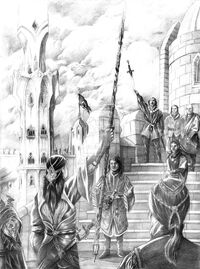
Gil-Galad and Elendil meeting at Amon Sûl, by Abe Papakhian.
In TA 861, Arnor was divided into the kingdoms of Arthedain, Cardolan and Rhudaur. Weathertop stood at the junction of their borders, and became the focus of a long-running territorial dispute between the three kingdoms, with frequent border skirmishes and minor wars. During this time, Weathertop may have changed hands on several occasions. By the latter part of the 14th century, Weathertop was controlled by Arthedain and Cardolan, which were at that time allied against Rhudaur and Angmar, and was the chief fortress in their fortified border with Rhudaur. The watchtower and fortifications were burned and destroyed in TA 1409 by forces of the Witch-king.
King Arveleg I was slain while defending the watchtower, but the Dúnedain of Arthedain saved the Palantír and took it to their capital at Fornost. By the time of the War of the Ring only a ring of broken stonework remained of the watchtower.[2]
Etymology
Weathertop was the common Bree-land name of the hill, and is self-descriptive; the summit of the mountain was almost always windy, due to its prominence. Its Sindarin name, Amon Sûl, meant Hill of the Wind.
Portrayal in adaptations

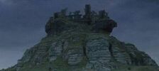
Weathertop at night, from the film.
The Lord of the Rings film trilogy
Weathertop is a scene of action in the Peter Jackson film The Fellowship of the Ring (2001). After fleeing from Bree, Strider and the hobbits avoid the main road and approach Weathertop from the north. At the top they discover a cairn with a message from Gandalf, and see the Ringwraiths approaching in the distance along the road. That night, the Ringwraiths attack their camp in a dell below the summit, stabbing Frodo with a Morgul blade before being driven off.
The Hobbit film trilogy
In the film The Hobbit: An Unexpected Journey (2012) Weathertop appears briefly as a meeting place for Yazneg, Fimbul, Azog and his warg riding hunters.
Filming Location
The hill that Weathertop was filmed at is on a large farm near Port Waikato, in the Waikato Region of New Zealand. The area surrounding has many limestone cliffs and boulders, some of which contain fossils.

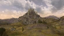
Weathertop as it appears in The Lord of the Rings Online, here seen at night
The Lord of the Rings Online
Weathertop appears as a playable location in The Lord of the Rings Online, where it is portrayed as a significant hill in the Lone-lands region.
Gallery
")
")
")
")
Translations around the world
| Foreign Language | Translated name |
| Basque | Haizeen tontorra |
| Catalan | Pica del Vent |
| Chinese (Hong Kong) | 風雲頂 |
| Croatian | Vrijeme vrh |
| Czech | Větrov |
| Dutch | Weertop |
| Esperanto | Veterverto |
| Finnish | Viimapää |
| French | Mont Venteux |
| German | Wetterspitze |
| Hebrew | גבעת הרוחות |
| Hindi | मौसम का शीर्ष |
| Hungarian | Széltető |
| Italian | Colle Vento |
| Marathi | हवामानशाळा |
| Nepalese | मौसम शीर्ष |
| Norwegian | Værhø
Blåstertopp |
| Polish | Wichrowy Czub |
| Portuguese | Monte do Vento (Portugal)
Topo do Vento (Brazilian Portuguese) |
| Romanian | Țancul Vremii |
| Russian | Ваветрень |
| Spanish (Spain and Latin America) | Cima de los Vientos |
| Swedish | Väderklint |
| Turkish | Fırtınabaşı |
| Ukrainian Cyrillic | Вітровий пагорб |
|
Places of Middle-earth and Arda
Middle-earth Locations:
Provinces/Regions: Arnor | Dunland | Ettenmoors | Forochel | Forodwaith | Gondor | Harad | Ithilien | Khand | Lindon | Minhiriath | Mordor | Rhovanion | Rhûn | Rivendell | Rohan | The Shire Forests & Mountains: Amon Dîn | Amon Hen | Amon Lhaw | Caradhras | Emyn Muil | Erebor | Fangorn Forest | High Pass | Iron Hills | Lórien | Mirkwood | Mount Doom | Mount Gundabad | Old Forest | Orod-na-Thôn | Tower Hills | Weathertop Hill City/Fortifications: Angband | Barad-dûr | Bree | Caras Galadhon | Dol Guldur | Fornost Erain | Hornburg | Isengard | Minas Morgul | Minas Tirith | Last Homely House | Tower of Amon Sûl | Tower of Orthanc | Osgiliath | Umbar | Utumno Miscellaneous: Argonath | Astulat | Buckland | Cair Andros | Dagorlad | Dead Marshes | Enedwaith | Fords of Isen | Gap of Rohan | Grey Havens The rest of Arda:
Aman | Burnt Land of the Sun | Dark Land | Empty Lands | Neldoreth | New lands | Númenor | Tol Eressëa |
References
- ↑ The Atlas of Middle-earth, The Lord of the Rings, "Weathertop"
- ↑ The Lord of the Rings, The Fellowship of the Ring, Book One, Chapter XI: "A Knife in the Dark"